Tallulah Gorge_Suches - 197 Miles
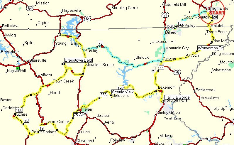
Tallulah Gorge_Suches_197
This route drops off the Highlands mountain to the south, and takes in the
optional stops of Tallulah Gorge, Helen, Two Wheels Only Motorcycle Resort
and Brasstown Bald (highest point in GA).
Get on 28 South from Highlands (take 106, then turn right onto 28.
At mile 11 (Pine Mountain) make a left onto Warwoman Drive. (NOTE-For GPS
users, there's a glitch at Pine Mountain that I can't fix, but watch for
Warwoman to the right at mile 11).
Follow Warwoman Drive into Clayton, GA, and turn left onto Hwy 23, and head
south to Tallulah Gorge. Tallulah Gorge Visitor and Interpretive Center is a
paid stop, and includes a nicely cleared path down into the gorge for photo
ops of the falls and river at the bottom. Worth the time if you're
interested. If not, just cut short at Lake Rabun Road and head toward Helen.
Lake Rabun Road is a slow, tight, twisty, high income lake housing
development that is both fun to ride and gorgeous to see. Slow down and
enjoy the homes and lake views.
Make a left on hwy 197, then a couple miles down, make a right onto Hwy 356.
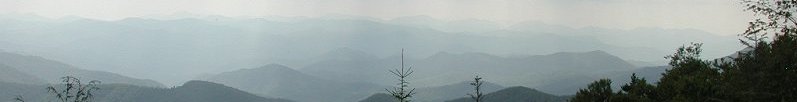
When the weather is right, there's a beautiful view just after turning onto
356. 356 will take you to Hwy 77. At 70 miles, Helen is your first meal
opportunity. If you're hungry, turn left and stop anywhere in Helen, and if
not, make a right on 17, then make a left onto Hwy 75-ALT and follow it to
Hwy 129. Turn right on 129, then at Turners Corner, turn left onto 19.
Turn right onto Hwy 60, and follow it aprox 7 miles. You'll see Two Wheels
Only Motorcycle Resort on the left. Feel free to stop and stretch a bit, and
they have drink machines on the porch. Just past TWO, make a right onto
Wolfpen Gap Rd (Hwy 180)
Hwy 180 will take you all the way back to Hwy 17 north of Helen. It will
merge with 129 for a couple of miles, so just follow the signs. You will
also pass the entrance to BrassTown Bald, the highest point in Georgia. If
the weather is good and you wish to spend some time there, it is a paid
parking facility (with restrooms), and you are well advised to pay for the
van ride to the top. Otherwise, be prepared for a heart pounding hike to the
lookout tower and visitor center!
Make a left on Hwy 17 and head north to Hiwassee. At mile 140. Hiwassee is
your second lunch opportunity. Crossroads Cafe is on the northern end, and
is a "country cooking" type restaurant, but there are other fast food
choices along the way. This is also a good time to gas up.
From Hiwassee, take Hwy 76 back to Clayton, and turn left onto Hwy 23. Just
past Dillard, watch for Hwy 246 (Larry McLurrie Hwy) (gas station and hotel
at this intersection). Make a right onto 246, which will become 106 (Scaly
Mountain Rd) and take you back to Highlands.
Note: Approaching Dillard from the south, if the weather is good and the
water table is up, you can see a huge waterfall way up in the mountains on
your right! Keep an eye out for it! :-)
Directions
1.) On the west end of Highlands, turn left on Hwy 106, go
2/10ths of a mile, then turn left onto Hwy 28.
2.) Turn right on Warwoman Drive near Pine Mountain
3.) Turn left on Hwy 23 at Clayton
4.) Go 11.2 miles and follow the signs into Tallulah Gorge Park on right
(This is a pay area).
5.) Go back up Hwy23 three miles and make a left on Joy Bridge road to cut
over to Old GA 441 (Right on Old 441)
6.) Turn Left on Lake Rabun Road
7.) Lake Rabun Road becomes Seed Lake Road, then bear left onto Burton Dam
Road
8.) Turn Left on Hwy 197
9.) Turn Right on 356
10.) Turn Right Hwy 17, then left on Hwy 75Alt
11.) Turn Right on Hwy 129
12.) Turn Left on hwy 19 at Turner's Corner
13.) Turn Right on Hwy 60
14.) At Two Wheels Only Bike Camp, Turn Right on Hwy 180
15.) 180 merges with 129 for about two miles, then Turn Right to continue on
180.
16.) Turn Left on Hwy 17
17.) go into Hiwassee for lunch, then come back to Hwy 76 and head East to
Clayton.
18.) At Clayton, turn left on Hwy 23 and head north to Dillard.
19.) Just past Dillard, turn right on 246, which becomes 106 in North
Carolina (Scaly Mountain Rd).
20.) Turn Right on 64 at Highlands and head back to the hotel
Right Click the link above and select "Save Target As"
Right Click the link above and select "Save Target As"